
|
|
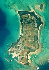
Tsukenjima
one of Okinawa's 8 Yokatsu Islands
Published: March 10, 2020
Edited: March 25, 2020
I anticipate having a lot more first-hand info and photos in Oct-Nov this year!
|
Tsuken Island (JP: Tsuken-jima, Okinawan: Biti) is an island in the Pacific Ocean in Uruma, Okinawa Prefecture, Japan. The island is southernmost of the Yokatsu Islands, and is located 3.8 kilometres (2.4 mi) south south-east of the Katsuren Peninsula off Okinawa Island at the entrance of Nakagusuku Bay. Tsuken covers 1.88 square kilometres (0.73 sq mi) and has a population of 487 residents.
The only settlement on Tsuken is located in the southwest of the island. The settlement includes the Port of Tsuken, a post office, and a medical clinic attached to the Okinawa Prefectural Chubu Hospital in Uruma. The island is home to Tsuken Elementary School (19 students) and Tsuken Junior High School (11 students). The island has no high school; students must leave the island after junior high school to continue their education. While residents of Tsuken speak standard Japanese, usage of the Okinawan language remains strong on the island, specifically the South-Central dialect of the language. ¹ (these demographics may not be current in 2020)
Geography
The central and northern parts of Tsuken are used for the production of carrots, a noted agricultural product of the island.
History
The areas of present-day Uruma were affected in World War II during the initial part of the Battle of Okinawa. L-Day, the initial land invasion of Okinawa Island, occurred on April 1, 1945. American forces swept across the island quickly, and by April 5 had secured the entirety of the Katsuren Peninsula. A smaller invasion force invaded the Yokatsu Islands on L-Day, and encountered stiff resistance from the Japanese military. Tsuken Island was completely devastated by fire in the battle. After the capture of Tsuken, American forces swept north and reached Ikei Island on April 9, thus securing all the Yokatsu Islands. Tsuken is in a period of population decline. In 1970 the island had 1,172 residents and 245 households; by 2005 the population was at 485 residents and 210 households.
Economy
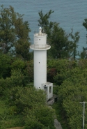
Transportation
Military training area
|
Today the people of Tsukenjima enjoy a quiet and peaceful existence but such wasn't the case back in 1945. In fact, the island was the site of some pretty gruesome fighting and dying - on both sides. There are still reminders of the fierce battles that took place along the southern and southwestern shores of Tsukenjima.
Many Imperial Japanese Army (IJA) and Okinawan conscripts' remains are still buried in caves and a large shelter beneath and among the ruins of Arakawa Castle in the south end of the island. The first direct American army attack occurred April 10, 1945.
Three Tsukenjima residents, Asato Yoshizo, Midorima Haruko, and Oishi Toyo, conscripted by the IJA just before the battle began, [carried out] Home Guard or nursing duties [and] experienced the battle [along] with the Japanese soldiers. ² The garrison on Tsukenjimma, under command of Captain Teishima Hideo, included 350 soldiers, 70 Home Guard (Okinawans) and approximately 60 men from the 15th Independent Mixed Regiment (Okinawan conscripts and other IJA soldiers typically composed of various units detached from other formations. Some were composed of separate, independent assets (usually Independent Infantry Battalions). These brigades were task-organized under unified command and were normally used in support roles, as security, force protection, POW and internment camp guards and labor in occupied territories.)
The Arakawa Castle shelter, where the three Tsukenjima residents claim that many bodies still remain unrecovered, was originally a natural cave where locals paid their respects to the spirits of members of the ancient warrior class. They constructed a three-story structure inside the hill [upon which the castle was built] that is the only protrusion on the otherwise flat island. It had a wooden staircase linking the floors [and] the lower level had an entrance which had been covered over before the American attack started.² Oishi says, "The Americans attacked a total of four times..." striking at night then returning to the main Okinawa Island. The first three attacks failed to achieve their goal. Japanese machine gun fire was successful in repelling the attacks and one witness recounts how the beach was red with the blood of American GIs who were gunned down. On the fourth attempt they approached from the north and worked their way south to the castle hill shelters. American forces poured gasoline into many caves above the shelter then ignited it. The upper levels' wooden floors and staircases burned ferociously. The explosions caused much of the cave shelter to collapse thus killing most of the injured soldiers and blocking the entrance.
Oishi said, "Thirteen of us nurses were ... down on the bottom floor of the shelter with some wounded soldiers. Fortunately the gasoline didn't flow down as far as we were, but the shells stored in the shelter exploded above us one by one ... [and] ... the interior was full of smoke." The nurses did what they could but with no supplies they had to take soiled bandages to the shore and wash them in sea water then return to use them again on the wounded soldiers who had survived. They were ordered by the captain in command to pack it up and return to Okinawa Island. After a few days, on April 24th, they returned to Tsukenjima.
"It was a journey fraught with danger as they carefully rowed the sabani boats forward or even back toward Okinawa , depending on the brightness of the U.S. flares in the sky. At this stage, about thirty or forty wounded soldiers were living by candlelight inside the Arakawa Castle Shelter with nurse's aides ... They carried the soldiers on stretchers (those stretchers included some that they had found that the Americans left behind) and headed for the beach to load them into boats. Part way through the process they heard American troops returning again and so they had to turn around and bring all of the wounded back into the shelter.
The fighting didn't last long. Only a very small number of soldiers were physically capable of resisting. The firefight soon ended with the Americans clearly in a position of advantage in firepower with eight tanks leading the way ... the troops surrounded the shelter and started calling for the people inside to surrender, yelling, "Dete-koi" and "dete-ki nasai" [meaning Come out!] through the entrance. Before long, one of the American soldiers peered into the shelter, an action that was to end in tragedy. A wounded soldier near the entrance stabbed the American soldier with his bayonet. Immediately the calls for those in the shelter to surrender stopped and the Americans started pouring large quantities of gasoline through the myriad of small holes at the top of what had been a natural cave. They then lit the gasoline which immediately burst into flames, with the wooden floor, the staricases, and the superstructure also starting to burn. Piles of ammunition exploded with the heat and rocks started to fall from above as the wooden beams burned and collapsed. The inside of the shelter had been transformed into a varitable scene from hell.² Midorima and Asato had been in an adjacent cave so didn't actually see the soldiers themselves but they know that their remains are still buried in the rubble of the collapsed cave. There is a memorial on top of the shelter cave, placed by the Tsuken-jima Bereaved Families Association. On it are inscribed the names of the people from Tsukenjima who lost their lives fighting in China or the Pacific, together with the names of Captain Teishima's garrison who had fled Tsuken Island only to be ultimately killed some time after their return to battle on the main Okinawa Island.
The memorial overlooks the playground of the Tsuken Elementary and Junior High School where young children are educated without a care in the world.²References: |

©2020 Contact: ClickOkinawa.com